Original Chester Park Survey (1890)
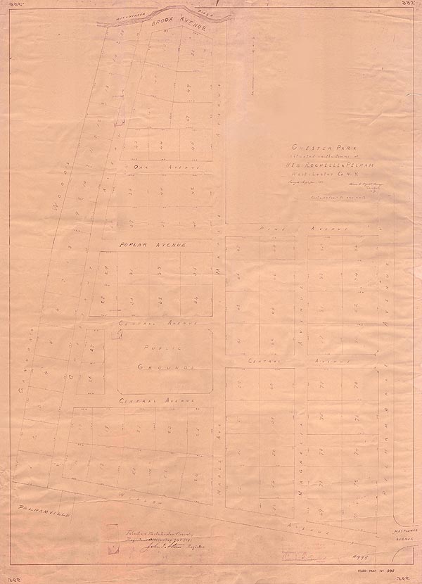
The above survey documents the precise boundary lines of the original 86 Chester Park lots offered for sale by William T. Standen. While the map is visually unimpressive, it reveals a number of historically significant and intriguing details about Chester Park in its infancy.
The map confirms that Chester Park was "Surveyed May and June, 1890" and "Filed in [the] Westchester County Register's Office Aug. 20th, 1891."
The original 86 lots averaged 100 by 100 feet, with the Northeast corner (above Pine and Maple) left undeveloped.
The Park was only accessible via Pelhamdale Ave. The connection to Third Ave. off of Willow is not shown.
The reference to "Public Grounds" on the map served as a key defense against efforts by the Town to foreclose on the Green and sell it for development in the 1950s.
The north ends of Maple and Chestnut Aves. were connected by a short street bordering the Hutchinson River called "Brook Ave."
Linden Ave. was originally known as "Magnolia Ave."
Walnut and Birch Aves. were considered extensions of Central Ave. and not given separate names until later.
The private drive running through the West end of the Green was part of the development's original plan.
The woods behind Chestnut Ave. were known as "Gannon's Woods."
The Chester Park Association is indebted to Jacque Padula of 38 Maple Ave. for donating this map to the Association's archives.